Research Topics
Obtaining Low-Cost Planetary Boundary Layer Observations With Kites
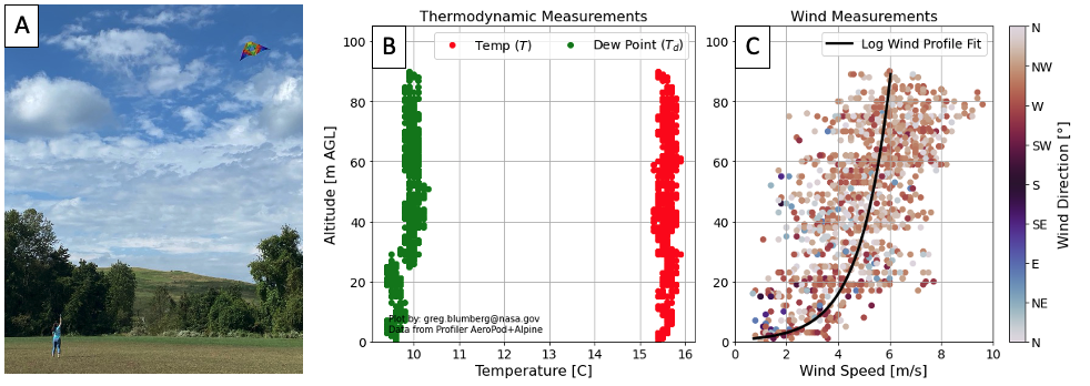
Although we live in the Planetary Boundary Layer (PBL), regular distributed observations of the PBL properties are sparse. To help fill this observational gap, I have been deploying kites with weather instruments in various locations. The kites and instruments are provided by my collaborators in the AEROKATS and ROVER Educational Network (AREN). I am also exploring the ability of kites to lift lightweight, low-cost instruments that can provide profiles of air pollution, trace gases, turbulence measurements, and allergens. Through the use of kites and lightweight detectors, we can create distributed networks of PBL observations that can help us quantify emissions of pollutants and improve weather models.
Aerosol Upwelling by Orography in Northern Thailand
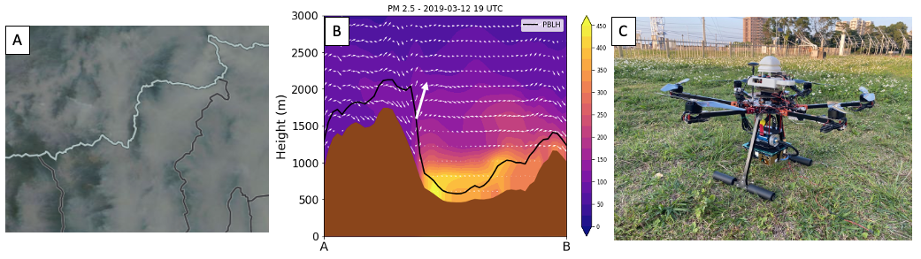
Every spring in Thailand is dominated by significant biomass burning which impacts the health of people and impacts the regional weather and climate. Also unique to this region is the terrain, which is dominated by multiple valleys and mountain ranges. While it is known that these geographic features play a role in modulating the pollution, not much is known about the specifics to this region. To investigate this further, observations (AERONET, sUAS profiles of aerosols and meteorology) and coupled regional models (NASA Unified-WRF, NASA’s Land Information System) are combined. This work is a part of Dr. Blumberg’s postdoc and is performed with collaborators at Taiwan’s National Central University as a part of the 7-SEAS Mission.
Improving Explosion Risk Predictions with 3D Weather at Launch Ranges
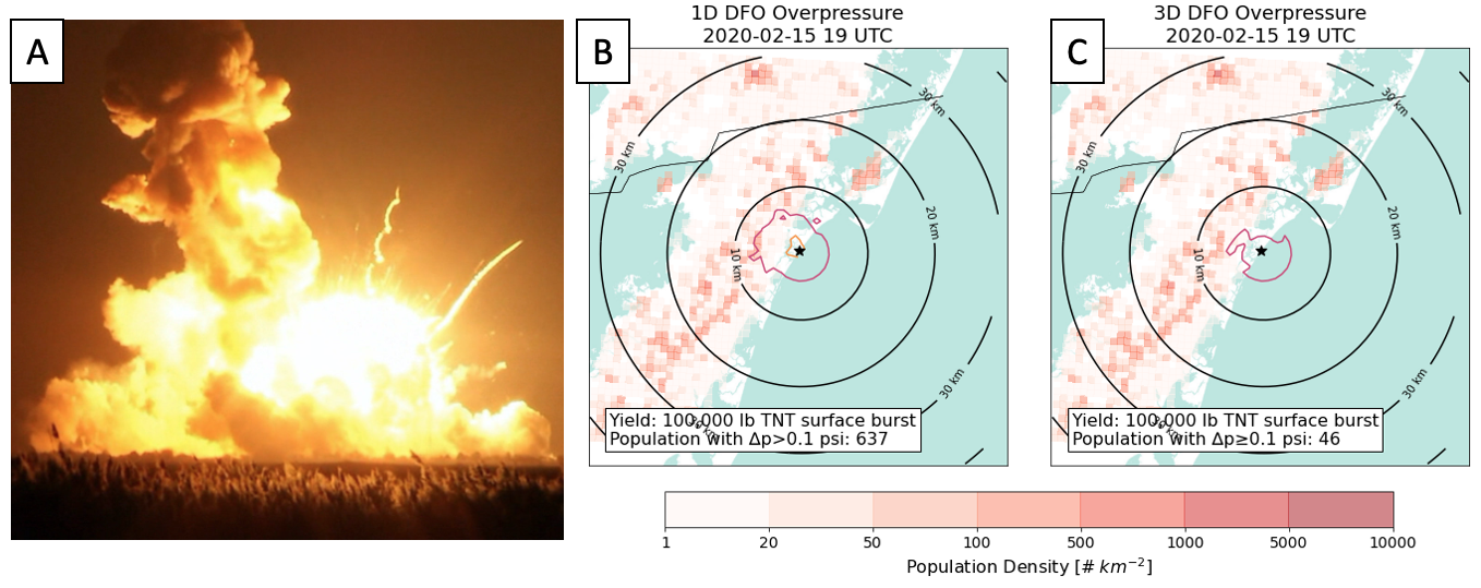
At launch ranges, the regional meteorology plays an important role in impacting the various hazards associated with launch vehicles. One hazard includes the distant focusing overpressure (DFO) risk, where the blast wave from a large explosion may be amplified by atmospheric properties. While at NASA, I reinvigorated this area of applied meteorology research by improving upon a 50+ year old assumption used widely in DFO risk assessments by incorporating the 3D weather from a numerical weather prediction model. These improvements can help reduce DFO false alarms, therefore increasing launch availability and reducing costly delays. This work has been presented to and influenced by members of the Space Force, NASA, FAA, and private businesses and is conducted in collaboration with the Wallops Safety Office. I am currently leading efforts to advance DFO-related range safety practices with the Range Commanders Council’s DFO Common Standard Working Group and act as a meteorology subject matter expert for the FAA’s Commercial Space Transportation division. I was recently invited to present my DFO work at the In.
- Blumberg, W. G., and A. Fadl, 2022: Effects of environmental heterogeneity on distant focusing overpressure risk assessments at coastal space ports. Journal of Space Safety Engineering, in review.
Southern Great Plains Afternoon to Evening Transition
The Southern Great Plains are widely know by meteorologists and storm chasers to experience a climatological increase in severe weather hazards near sunset. Commonly, this increase is attributed to the development of the nocturnal low level jet, which arises due to a.) topographical and b.) dynamical reasons from the loss of turbulent mixing in the boundary layer. In this work, I analyzed using boundary layer observations and the Oklahoma Mesonet this time period - called the Afternoon to Evening Transition (AET). As moisture is a key ingredient for severe weather, I focused on studying the processes and consequences of rapid jumps in moisture that occur during the AET. This work established that local and non-local processes are responsible for this, and are dependent upon the land-surface conditions such as the Winter Wheat Belt. Importantly, this work identified that the AET moisture jumps can rapidly increase the convective instability (e.g., CAPE) in spite of the decreasing temperature due to the loss of sunlight.
- Blumberg, W. G., D. D. Turner, S. Cavallo, J. Basara, A. Shapiro, and J. Gao, 2019: An Analysis of the Processes Affecting Rapid Near-Surface Water Vapor Increases during the Afternoon to Evening Transition in Oklahoma, J. Appl. Met. Climo., 58, 2217-2234, doi:10.1175/JAMC-D-19-0062.1
Weather Communication In Neurodiverse Populations
With an increasing interest in using the social sciences to compliment goals within the meteorological community, there has been an increasing interest in tuning communication strategies for different communities. This novel work sought to look at how various Autism Spectrum Condition traits impact the psychological value, significance, and attunement individuals have towards the weather and its changes (known as weather salience). We hypothesized that systemizing - an attention to detail and a preference towards creating logical rules to explain nature - plays a role in this process. Research in this area demonstrated that autistic individuals display a higher weather salience than those without the condition, and helped develop an initial conceptual model that uses chaos theory and systemizing to understand the various degrees of weather salience individuals present.
- Bolton, M. J., W. G. Blumberg, L. K. Ault, H. M. Mogil, and S. H. Hanes, 2020: Initial Evidence for Increased Weather Salience in Autism Spectrum Conditions, Weather, Climate, and Society, 12 : 293-307, doi:10.1175/WCAS-d-18-0100.1.
PBL Thermodynamic Retrievals
Retrievals are an essential component of any remote sensing system. Because these measurements do not directly observe the variables we wish to analyze, mathematical algorithms must be used to transform the variables. For example, a measurement of radiation intensity can be linked to atmospheric temperature by through the principles of radiative transfer. In the case of the planetary boundary layer, we wish to know more about how profiles of temperature, humidity, and aerosols are evolving in time and space. My work in this area has focused around developing thermodynamic retrieval algorithms for the Atmospheric Emitted Radiance Intereferometer (AERI) and ground-based microwave radiometers (e.g., HATPRO, Radiometrics). An additional step has been the validation of these retrievals for use in the prediction of severe weather hazards.
- Turner, D. D. and W. G. Blumberg, 2018: Improvements to the AERIoe Thermodynamic Profile Retrieval Algorithm, IEEE Sel. Top. Appl. Earth Obs. Remote Sens., doi:10.1109/JSTARS.2018.2874968.
- Blumberg, W. G., T. J. Wagner, D. D. Turner, and J. Correia Jr., 2017: Quantifying the accuracy and uncertainty of diurnal thermodynamic profiles and convection indices from the Atmospheric Emitted Radiance Interferometer, J. Appl. Met. Climo., 56, 2747-2766, doi:10.1175/JAMC-D-17-0036.1
- Blumberg, W. G., D.D. Turner, U. Loehnert, and S. Castleberry, 2015: Ground-based temperature and humidity profiling using spectral infrared and microwave observations. Part II: Retrieval performance in all-sky conditions, J. Appl. Met. Climo., 54, 2305-2319, doi:10.1175/JAMC-D-15-0005.1